
Geographical Setting
Kraški rob (karst edge) is one of the most prominent geomorphological structures of western Slovenia, a more than 40‑kilometre‑long escarpment extending from the Gulf of Trieste near Muggia and Socerb, across Osp, Mišja Peč, Črni Kal, Podpeč, Zazid and Podgorje, continuing towards Movraž and terminating above the valley of the River Reka. Its position forms a natural boundary between two fundamentally different landscapes: the elevated carbonate plateau of the Classical Karst to the northeast and the lower, flysch‑dominated terrain of Slovenian Istria to the southwest. This transition is not only topographic but also climatic and biogeographical, as sub‑Mediterranean influences meet continental ones, creating exceptional ecological diversity. As a relief feature, Kraški rob (karst edge) lies entirely within the territory of the Republic of Slovenia.
Geology and Formation
The formation of Kraški rob (karst edge) is the result of a long interplay of tectonic uplift, fault activity and selective erosion, which together produced one of Slovenia’s most striking tectono‑erosional escarpments. Its core consists of thick Cretaceous and Eocene limestone beds uplifted along Dinaric faults, while the lower slopes are built of softer flysch. The sharp contrast between the resistant carbonate cap and the erosion‑prone flysch base enabled the development of the escarpment, today characterised by vertical cliffs, overhangs, collapse amphitheatres and isolated rock towers. On the plateau surface, karst corrosion dominates, dissolving the limestone and forming karren, dolines, caves and underground drainage systems, whereas the lower slopes are shaped by surface erosion, landsliding and rockfall.
Kraški rob (karst edge) extends from the north at Socerb and Trieste to its southern culmination above Sočerga, where the monumental Veli Badin—known as the “Ears of Istria”—rises above the landscape. The entire structure reflects the multi‑phase geological evolution of the Adriatic carbonate platform, uplifted by Dinaric tectonics above the flysch basin of Istria. Neotectonic uplift during the Quaternary further accentuated the escarpment and produced an exceptionally sharp lithological and geomorphological boundary unparalleled in Slovenia.
The upper part of the escarpment is composed of compact limestones formed in a shallow, warm and biologically active sea. Their strength allows the development of vertical cliffs and overhangs, while the rhythmic alternation of marls, sandstones and siltstones in the underlying flysch creates a substrate that weathers rapidly and retreats. This lithological contrast is the fundamental condition for the formation of the escarpment: limestone remains elevated while flysch erodes away. Around Sočerga this boundary is exceptionally sharp—almost cut—producing the most dramatic geomorphological forms along the entire Karst Edge.
The tectonic structure of Kraški rob (karst edge) is linked to the Dinaric fault system trending northwest–southeast. The Socerb Fault uplifts the northern part above the Gulf of Trieste, the Osp–Črni Kal Fault shapes the central cliffs of Osp and Mišja Peč, while the Movraž–Sočerga Fault uplifts the southern section culminating in Veli Badin. The southern part is uplifted most strongly, explaining why Veli Badin is the most imposing and morphologically expressive segment of the entire system.
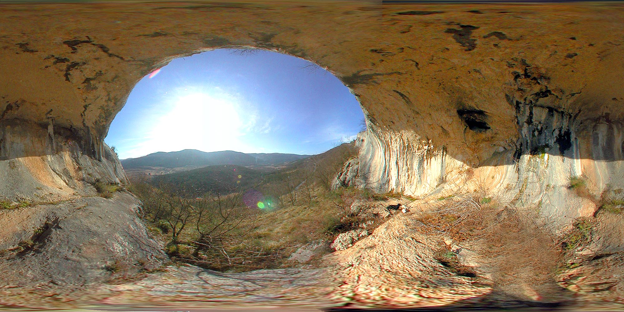
Once the tectonic framework was established, selective erosion began to sculpt the present landscape. The soft flysch weathered rapidly, while the limestone remained elevated. This produced the vertical walls of Osp, the overhangs of Mišja Peč, the collapse amphitheatres at Podpeč and Zazid, and the monumental overhangs of Veli Badin. The southern part of the escarpment is the most dramatic: erosion has undercut the limestone so deeply that a natural bridge and towering overhangs—opening towards Sočerga—were formed. This is a textbook example of an undercut carbonate escarpment shaped by the combined action of gravity‑driven processes, tectonic fracturing and flysch erosion.
On the plateau surface, classical karst processes dominate, dissolving the limestone and forming karren, dolines, rills and underground conduits. Water infiltrates through fractured limestone and collects in subterranean systems draining towards the springs of the Rižana, Dragonja and the Brkini region. The escarpment is a hydrogeologically important watershed where three drainage systems meet. Due to its elevation and exposure to wind and precipitation, corrosion processes are intense, deepening fissures and expanding karst forms.
Kraški rob (karst edge) is an area of continuous geomorphic activity. Tectonic fracturing of the limestone and erosion of the flysch cause frequent rockfalls, collapses and block movements. The most dramatic examples occur at Veli Badin, where massive limestone blocks have slid over the flysch base, forming a stepped slope descending towards Sočerga. Similar processes occur at Podpeč and Zazid, though nowhere as prominently as in the southern section.
A special issue is the continuation of Kraški rob (karst edge) into Croatia. Geomorphologically, the escarpment ends at Veli Badin: south of Sočerga, limestone disappears from the surface, flysch governs the relief, the escarpment loses its height contrast and the landscape transitions into the softly undulating hills of Croatian Istria. Geologically, however, the lithological boundary between limestone and flysch continues towards Buzet and the Ćićarija range, though without forming an elevated escarpment. Kraški rob (karst edge) is therefore a geomorphological feature unique to Slovenia, while the geological continuity of the carbonate platform extends further but without the characteristic relief expression.
Veli Badin is thus both the climax and the terminus of Kraški rob (karst edge). Its overhangs, natural bridge and collapse amphitheatre result from the intense interaction of tectonics, erosion and gravity. Because the slope beneath Veli Badin descends directly towards Sočerga, this part of the escarpment is the most dramatic and visually striking. For this reason, the overhangs are known as the “Ears of Istria”—from Sočerga and from the Croatian side they rise as a monumental natural backdrop marking the southern end of Kraški rob (karst edge).
History and Settlement
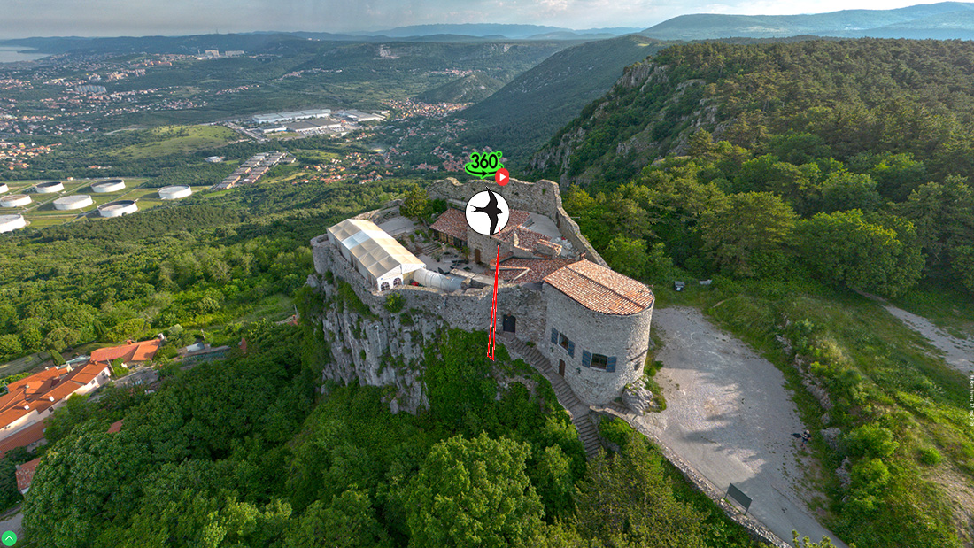
Because of its strategic position, Kraški rob has been inhabited since prehistoric times. Natural caves, overhangs and elevated terraces provided shelter and control over the routes connecting Istria with the interior. Socerb is one of the most historically significant peaks: its castle played a key role in medieval and early modern conflicts between the Venetian Republic, the Habsburgs and later various military forces of the 20th century. Beneath the cliffs of Osp, Podpeč and Zazid, fortified settlements developed, taking advantage of the natural protection of the overhangs and access to water sources at the flysch foot.
Terraced slopes, dry‑stone walls, remnants of shepherd paths and vineyard parcels testify to centuries of land use adapted to the demanding relief. Kraški rob also served as an important communication corridor, controlling routes between Trieste, Istria and central Slovenia. In the 20th century, the area gained additional strategic significance due to its proximity to the state border, influencing settlement patterns, economy and transport connections.
Settlements beneath Kraški rob
At the foot of Kraški rob lies a chain of villages forming a transitional belt between the karst plateau and the flysch hills of Slovenian Istria. Their location is determined by access to water, protection from the bora wind and control over passes between the Karst and Istria. Each village bears its own historical layer, architectural identity and landscape role.
Osp
Osp is the oldest Slovenian village, nestled beneath mighty limestone cliffs that today form a world‑renowned climbing area. It was already inhabited in prehistoric times thanks to the natural protection of the overhangs and a permanent spring. In the Middle Ages, it was part of the defensive system of the Venetian Republic. The architecture is distinctly karstic: stone houses with compact courtyards, paved alleys and dry‑stone walls. In landscape terms, Osp is a textbook example of harmony between human settlement and karst relief—the village literally leans against the cliff.
Črni Kal
Črni Kal lies at an important pass between the Karst and Istria and is today a major transport hub marked by its famous viaduct. In the centre stands a medieval tower that once controlled the route toward Trieste. The architecture is karstic, with limestone walls and stone roofs. The village spreads across terraces created through long‑term agricultural use. In landscape terms, Črni Kal forms a prominent lookout promontory above the flysch terrain.
Podpeč
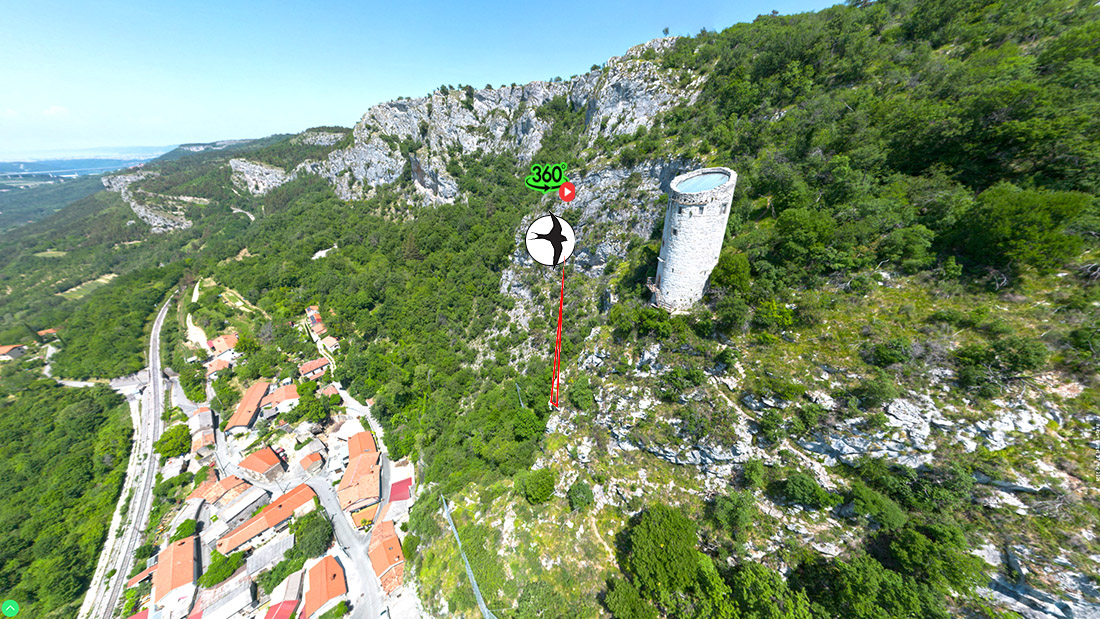
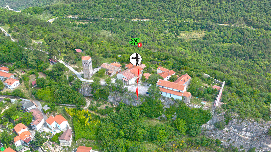
Podpeč lies beneath a rock overhang where a 13th‑century tower stands—one of the finest examples of fortified architecture along the Edge. The village was built near a spring and on terraces that allowed cultivation despite the steep terrain. Houses are stone‑built, with small windows and courtyards adapted to the slope. The overhang above the village forms a collapse amphitheatre of exceptional geomorphological and scenic value.
Zazid
Zazid is a high‑lying village along the Edge, surrounded by dry‑stone walls and terraces. In the Middle Ages it was a fortified outpost, as evidenced by remains of its walls. The architecture is karstic, with massive stone houses and narrow streets. In landscape terms, Zazid marks a distinct junction between the karst escarpment and the flysch hills, offering views toward the sea and the interior.
Podgorje
Podgorje lies on the flysch foothills below Mount Slavnik, where the karst and Istrian worlds meet. The village has always been an agricultural centre, known for livestock breeding, viticulture and fruit growing. Its architecture is transitional—the karst stone style blends with Istrian elements such as larger courtyards and warmer façade tones. In landscape terms, Podgorje serves as a starting point for ascents to Slavnik and exploration of the southern part of the Edge.
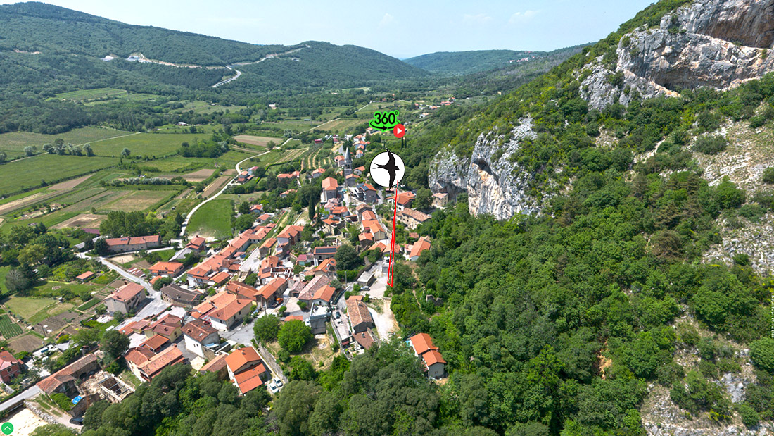
Hrastovlje
Hrastovlje lies in the valley of the Rokava stream, just below the limestone slopes of Kraški rob. The village is famous for the Church of the Holy Trinity with its renowned Dance of Death frescoes, among the most valuable art monuments in Slovenia. The architecture is Istrian, with low stone houses surrounded by olive groves and vineyards. Landscape‑wise, Hrastovlje is a hydrogeologically interesting point where karst springs meet flysch waters, enabling permanent settlement. The village is a cultural symbol of the transition between the karst and Istrian worlds.
Movraž
Movraž is a typical Istrian village with olive groves, vineyards and dry‑stone walls, lying just beneath the Edge where limestone gives way to flysch. It has a distinctly sub‑Mediterranean character, with low stone houses and terraced fields. The cliffs above the village mark the transition into the karst world. In landscape terms, Movraž represents a gentle passage from flysch hills to the limestone escarpment.
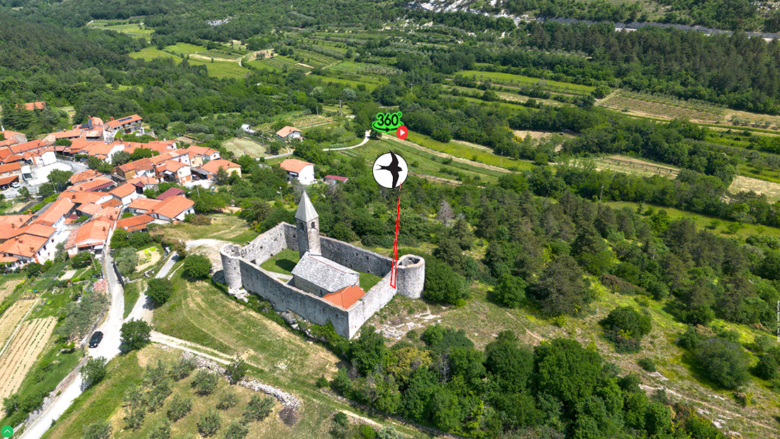
Kubed
Kubed lies between Movraž and Sočerga, on a natural terrace above the valley of the Rokava stream. Historically, it was a fortified post, as evidenced by the tower beside the Church of St. Florian. Stone houses and narrow streets follow the terrain, while olive groves and vineyards surround the village on flysch slopes. Kubed is a distinct transitional settlement between the karst and Istrian landscapes, where the limestone edge meets the softer flysch hills.
Sočerga
The southernmost village beneath the Karst cliffs, located on the Slovenian side of the border. It lies directly below Veli Badin, where the mighty overhangs known as the Ears of Istria rise above. Sočerga is a quiet Istrian village with a rich cultural landscape of olive groves, vineyards and dry‑stone walls. Its position beneath the Edge is exceptional: from here, one can view the flysch valleys and the limestone cliffs marking the end of Kraški rob.
Architectural and Landscape Synthesis
The villages beneath Kraški rob form a unified cultural belt linking the karst and Istrian landscapes. In the northern part, karst architecture predominates, with limestone walls and stone roofs; in the southern part, the Istrian style prevails, characterised by warmer tones, larger courtyards and olive groves. Terraced slopes, dry‑stone walls, shepherd paths and vineyard parcels bear witness to centuries of land use. Today, these villages represent a living cultural landscape where traditional agriculture, natural values and modern recreation intertwine.
Present‑day Significance
Today, Kraški rob is one of Slovenia’s most important natural and cultural landscapes. Owing to its exceptional biodiversity, the combination of karst and sub‑Mediterranean ecosystems and numerous rare species, much of the area is included in the Natura 2000 network. Veli Badin, Osp, Mišja Peč and Črni Kal are world‑renowned climbing areas attracting athletes from around the globe. Socerb remains an important cultural and tourist site, combining historical heritage with outstanding views.
Kraški rob is simultaneously a space of traditional land use—pastoralism, viticulture and olive growing—and modern recreation such as hiking, cycling and climbing. Despite this, it remains a sensitive landscape where natural values, cultural heritage and contemporary pressures intersect. Maintaining a balance between conservation and use is therefore a key challenge for the future.