Political system: democratic republic
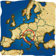
Location: Central Europe
Capital city: Ljubljana
Population: approximately 2 million
Nationality: Slovenian
- Total area: 20,273 km²
- Land: 20,151 km²
- Water surfaces: 122 km² (+ ~180 km² Adriatic Sea)
- Forest coverage: ~58%
- Highest point: Triglav – 2,864 m
- Lowest point: Adriatic Sea – 0 m (-32 m)
- Coastline length: 43,157 m
- Longest river: Sava – 221 km in Slovenia
- Largest natural lake: Lake Bohinj – 3.18 km²
- Precipitation: 800–3,500 mm/year
- Annual temperature: from 0°C (Kredarica) to 13°C (Portorož)
The average annual temperature in Slovenia ranges from approximately 0°C in the high mountains to 13°C along the coast, with a national average around 9°C–10°C. In recent decades, it has noticeably increased due to climate change.