

| Primary Spring Branch | Mala Ljubljanica (Močilnik) |
| Spring Morphology | Pocket valley (steephead) beneath the Devil's Rocks |
| Cliff Height (Devil's Rocks) | Up to 40 m |
| Main Vents | Veliki Močilnik and Mali Močilnik |
| Karst Catchment Area | Planina Polje (Unica), Logatec Plateau, Hrušica |
| Linear Distance (Unica Ponors - Močilnik) | Approx. 9.5 km |
| Elevation Difference (Ponor - Spring) | ~ 142 m |
| Confluence with Velika Ljubljanica | After ~ 1 km of flow near Vrhnika |
The Ljubljanica is one of the most remarkable karst hydrological systems in Europe. Although its official course under this name commences only at Vrhnika and spans approximately 41 kilometers to its confluence with the Sava River at Podgrad, the Ljubljanica is in reality the terminal surface segment of a monumental river basin spanning more than 100 kilometers that snakes through the karst underworld of Notranjska and central Slovenia.
Because of its repetitive sinking and resurgence cycles, the river has earned widespread fame in local lore and geography as the "river of seven names". The water that surges forth at Vrhnika begins its journey through successive poljes as:
- Trbuhovica (on the Prezid Polje in Croatia),
- Obrh (on the Lož Valley / Loško polje),
- Stržen (on the intermittent Lake Cerknica),
- Rak (through the dramatic Rakov Škocjan collapsed karst valley),
- Pivka (flowing through Postojna Cave and sinking in Pivka Cave),
- Unica (formed by the subterranean union of the Pivka and Rak within Planina Cave, traversing the Planina Polje),
- Ljubljanica, after sinking once again along the northern margin of Planina Polje and emerging at the southern rim of the Ljubljana Marsh.
From Vrhnika onward, the Ljubljanica settles into a gentle, meandering pace across the expanse of the Ljubljana Marsh (Ljubljansko barje). Its gradient across this stretch is exceptionally low (scarcely more than one meter over 20 kilometers as the crow flies), which historically rendered it prone to extensive flooding. After passing through the national capital Ljubljana—where its course is adorned by Jože Plečnik's iconic bridges, sluice gates, and the historic Gruber Canal—it cuts through the gorge between Golovec and Castle Hill, ultimately discharging into the Sava at Podgrad.
The Ljubljanica is also an extraordinary archaeological treasury. Thanks to its soft, oxygen-poor, silt-rich riverbed sediments, thousands of ancient artifacts have been preserved intact through the millennia—ranging from prehistoric pile-dweller relics (including the world's oldest wooden wheel with an axle discovered on the Marsh) to Roman weapons, tools, and medieval swords.
Močilnik – The Cradle of Mala Ljubljanica
The Močilnik Valley is a scenic karst pocket valley (steephead) situated immediately south of Vrhnika, enclosed beneath the sheer, vertical limestone ramparts known as the Devil's Rocks (Hudičeve skale), rising up to 40 meters high. It was sculpted by retrograde (backward) cavern collapse and groundwater dissolution, as pressurized karst conduits systematically carved away the limestone mass over hundreds of thousands of years.
At the head of Močilnik, two primary karst siphon vents emerge:
- Veliki Močilnik: The dominant resurgence vent, which surges turbulently from a deep submerged cavern at the base of the rock wall during high-water events.
- Mali Močilnik: A smaller, perennial spring located slightly downvalley that maintains a steady, continuous discharge.
The outflow from these vents forms the Mala Ljubljanica ("Lesser Ljubljanica"), which winds through the verdant valley floor. The site is intimately intertwined with ancient mythology: legend tells that the mythological hero Jason and the Argonauts sailed through here with the Golden Fleece while fleeing up the Danube, Sava, and Ljubljanica toward the sea. Confronted by the insurmountable barrier of the Devil's Rocks, they were compelled to dismantle the ship Argo and carry it upon their shoulders across the stony Karst plateau all the way to the Adriatic Sea.
Other Resurgences of the Ljubljanica
- Retovje (Velika Ljubljanica): The neighboring steephead valley near the village of Verd, hosting deep siphon springs (Pod skalo, Pod orehom, Malo and Veliko okence). After approximately one kilometer of flow, Velika and Mala Ljubljanica merge into the unified channel of the Ljubljanica.
- Bistra: A powerful cluster of karst resurgences at the foot of the forested Menina slope beneath the former Carthusian monastery (now the Technical Museum of Slovenia), feeding the Bistra Stream.
- Lintvern near Verd: A curious intermittent karst spring (vauclusian ebbing-and-flowing well) that discharges cyclically, famously documented as early as the 17th century by polymath Johann Weikhard von Valvasor.
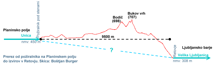
Hydrological cross-section showing subterranean conduits between Planina Polje and the Vrhnika springs