
Grad Kostel: history, early digital visualization, and the arc of restoration
Perched on a rocky spur above the Kolpa River near the Croatian border, Grad Kostel is among Slovenia’s most expansive fortified complexes. Its evolution reflects frontier realities: medieval lordship and oversight, the pressure of Ottoman incursions, Napoleonic disruption, and a long ruination that has, since the late 20th century, been steadily reversed. This essay traces the castle’s historical development, the first late-1990s digital visualization that preserved its pre-restoration state, the start of systematic conservation, and how the site’s appearance has transformed through ongoing work and public activation.
![]()
Historical development
Origins and Ortenburg phase (13th–14th centuries): A predecessor fort stood at the site before the Ortenburgs—vassals of the Patriarchate of Aquileia—strengthened and rebuilt the stronghold between roughly 1247 and 1325 to guard southern Carniola. The earliest recorded mention appears in 1336 as “castrum Grafenwarth,” signaling the dual identity of Kostel as both a watch over the Kolpa corridor and an administrative center.
Under the Counts of Celje (15th century): After the extinction of the Ortenburg line in 1418, Kostel passed to the Counts of Celje. Responding to intensified frontier threats, the castle was expanded into a sprawling defensive complex with outer walls and a structured inner settlement, placing Kostel immediately behind Celje Castle in overall extent.
Frontier pressures and settlement dynamics (16th century): Kostel’s position on a key incursion route made it central to regional defense. The site endured assaults and strategic depopulation pressures; historical accounts note the settlement of Uskoks in the 1530s as part of wider defensive repopulation policies.
Valvasor’s witness (1679): Johann Weikhard von Valvasor’s engraving captures Kostel’s vast enclosure and the presence of an internal market settlement—rare among Slovenian castles—affirming its lived-in character behind the walls.
Ruination and modern heritage status
Napoleonic rupture (1809): During the French administration, the castle was burned in 1809 and subsequently left unrestored. A “Lower Castle” settlement developed beneath the ruined upper complex, while the main enclosure eroded throughout the 19th and 20th centuries.
National protection (late 20th century): In 1999, Kostel was formally designated a monument of national importance, establishing conservation frameworks and a planning base for phased stabilization.
The first late‑1990s digital visualization and why it mattered
Pioneering 360° documentation: In the late 1990s, Grad Kostel was captured in pioneering 360° panoramic documentation. These panoramas—archived on burger.si—provided a public record of the castle’s condition before systematic restoration began, preserving states that later interventions would change.
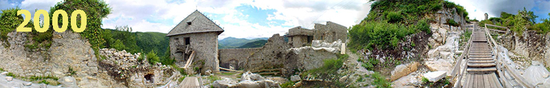 The state of the castle before restoration (archives 1990-2000)
Diachronic comparison: Read alongside Valvasor’s 17th‑century engraving, the late‑1990s panoramas create a robust diachronic pair: the engraving offers a schematic ideal, while the panoramas supply empirical evidence just prior to contemporary consolidation.
 Visualisation of Kostel Castle, 17th century (by www.mojaslovenija.si)
The start of restoration and key phases
Initiation around 1999–2000: Restoration began at the turn of the millennium. The first measures prioritized stabilization—shoring critical wall segments and securing tower edges.
2000–2010: Structural consolidation: Targeted conservation addressed the most vulnerable curtain walls and entrance zones, guided by archaeological checks.
2010–2020: Public activation: Kostel evolved into a cultural venue—tours, performances, and weddings—leveraging its rare feature: an inhabited area within the historic enclosure.
Since 2020: Interpretation and reconstruction studies: New interpretive layers—exhibits, digital guides, and 3D reconstruction attempts—help visitors understand the castle’s spatial logic.
How the castle’s appearance changed through restoration
The visual identity shifted from a heavily overgrown, fragmentary ruin into a recognizable, accessible complex. Stabilization of wall crowns and improved paths brought clarity to the site’s plan without erasing traces of ruination central to its modern narrative. The late‑1990s panoramic records now serve as a comparator for “before and after” analysis.
Name, meanings, and identity
“Kostel” traces to Latin castellum (fortified place), while “Grafenwart” signals a watch station of comital authority. The dual naming reflects its core identity: oversight of a strategic river corridor and governance of peripheral estates in a frontier milieu.
Closing perspective: Kostel’s path culminates in a patient, ethics‑focused restoration that privileges authenticity and public life. Today, the castle embodies a balanced model: minimally invasive structural care, clear interpretation, and community‑centered activation on Slovenia’s southeastern frontier.
Sources
- Zavod za kulturo in turizem Kostel (official presentations and historical overview)
- Ministry of Culture of RS, Register of immovable cultural heritage (monument status)
- Johann Weikhard von Valvasor, Topographia Archiducatus Carnioliae (1679)
- Grad Kostel – summary entries and syntheses in Slovenian guide literature
- burger.si – late‑1990s pioneering 360° panoramic documentation