

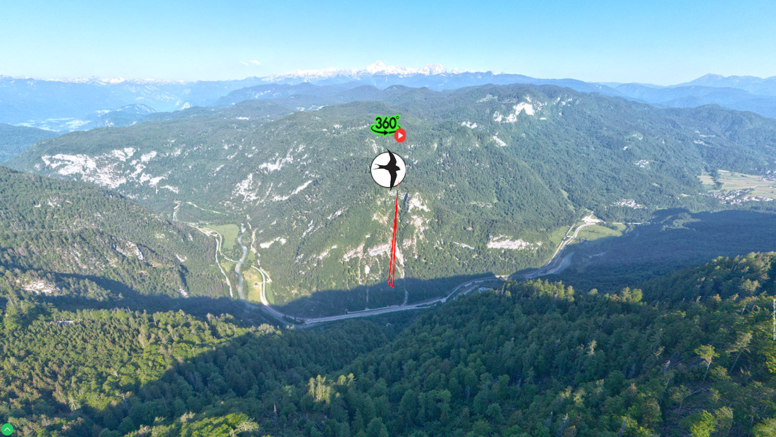
Jelovica is an extensive high‑karst plateau on the northern edge of the Gorenjska region, positioned between four distinct valley systems that frame it naturally and emphasise its elevated, plateau‑like character. To the south it is bordered by the Selca Valley in the west and the Lipnica Valley in the east, while to the north the plateau breaks off steeply towards the Sava Bohinjka and Radovna valleys. This position between deeply incised valleys creates a strong contrast between the cool, forested plateau and the warmer, settled valleys below.
To the west, Jelovica connects with the Pokljuka plateau via saddles and wooded ridges, forming a unified high‑karst system. To the east, the plateau gradually descends towards Kropa, Jamnik and Dražgoše, where its edges are dissected by steep ravines and slopes.
Size and Extent
Jelovica covers approximately 60 km² (up to 70 km² in a broader geomorphological sense), making it one of the largest continuous forested areas in Slovenia. In plan view, the plateau is elongated in an east–west direction and spans between 6 and 10 kilometres in width. Its size and dense forest cover give it the character of a pronounced natural barrier between the northern and southern parts of Gorenjska.
Elevation and Relief
The elevation of Jelovica ranges from 900 to 1,400 m, with most of its surface consisting of gently undulating high‑karst terrain. The highest part lies around Partizanski vrh (1411 m), which also bears the traditional name Jelovica, a dual naming that historically caused confusion between the plateau and the summit.
Partizanski vrh (1411 m).
Dual Naming of the Summit
The highest edge of the plateau is, in older sources and local usage, often referred to simply as Jelovica, which historically caused confusion between the name of the plateau and the name of the summit. After the Second World War, when the area was arranged as a memorial site, the name Partizanski vrh (“Partisan Peak”) became established and is now the official name. In practice this means:
-
Partizanski vrh = the official summit name,
-
Jelovica = the name of the plateau, but also a traditional local name for the same summit.
The edges of the plateau are markedly asymmetrical:
-
the northern edge is steep, in places almost precipitous, offering views towards Bohinj, Gorje and the Radovna Valley,
-
the southern edge is more gradual, with forested slopes descending towards the Selca and Lipnica valleys.
Access and Transport
Jelovica is sparsely populated and has limited road access, which contributes to its preserved natural character. Access to the plateau is provided mainly by forest roads:
-
from Dražgoše,
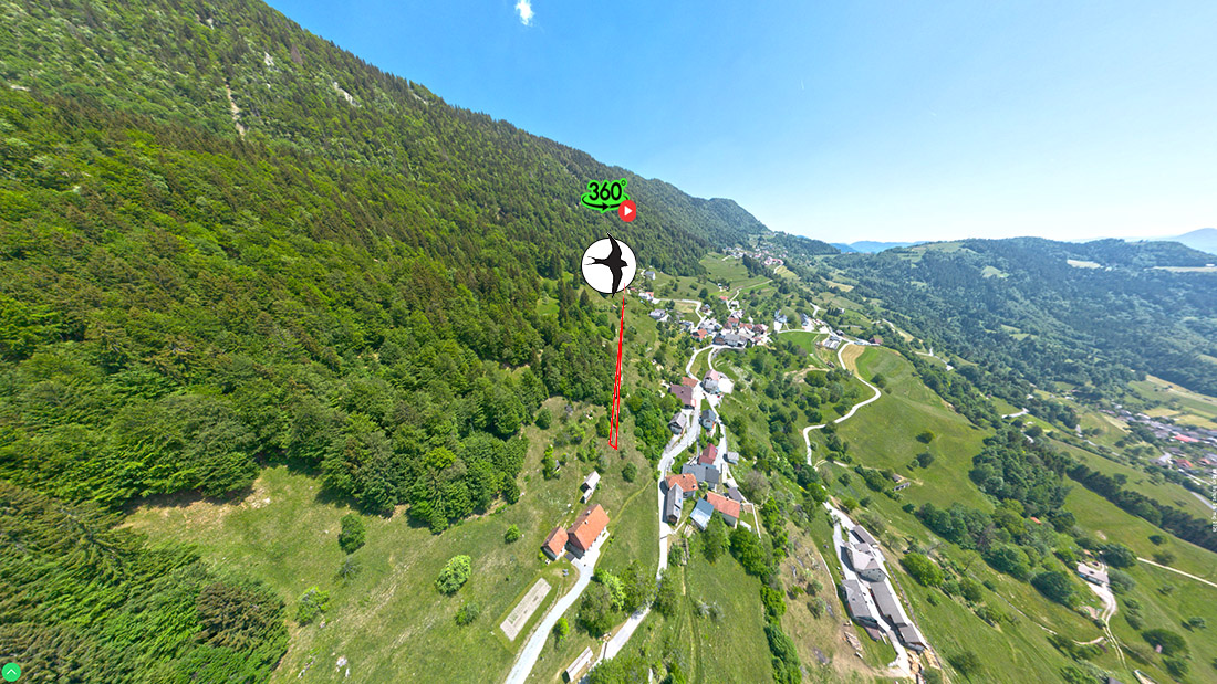
-
from Kropa and Jamnik,
-
from Gorje and Krnica,
-
from Bohinjska Bela via the Reber ridge.
Due to its varied relief and dense forest cover, the interior of the plateau is interwoven with forest tracks, while there are no permanent settlements on the plateau itself.
Position in the Wider Landscape
Jelovica lies at the junction of:
-
the Julian Alps (in a broader geomorphological sense),
-
the Prealpine belt,
-
and the Central Slovenian Basin.
This transitional position is reflected in its climate, vegetation and historical land use. The plateau also forms a natural divide between Bohinj and the Gorenjska plain, and serves as an important catchment area for several rivers that rise along its margins.
Mountain Range and Geological Structure
Jelovica belongs to the Prealpine belt on the eastern margin of the Julian Alps. It is a typical high‑karst plateau, built of Mesozoic limestones and dolomites.
Characteristic features include:
-
numerous dolines, karst depressions and blind valleys,
-
absence of surface streams, as water quickly infiltrates into the ground,
-
extensive subterranean karst drainage, feeding springs in the surrounding valleys (e.g., Lipnica, Selška Sora).
Along the edges of the plateau, small patches of morainic and glacial deposits testify to the influence of Pleistocene glaciation.
Nature and Ecosystems
Jelovica is almost entirely forested, giving it a strong sense of remoteness and wilderness.
Key natural elements:
-
spruce and beech forests, locally mixed with maple, alder and mountain ash,
-
high‑altitude peat bogs (e.g., Blato, Ledine), important for water retention and rare species,
-
forest clearings – remnants of former pastures and hay meadows,
-
rich fauna: red deer, roe deer, capercaillie, hazel grouse, Ural owl, lynx, brown bear.
The climate is cooler than in the valleys, with frequent morning fog and a long‑lasting snow cover.
Protected Areas
Although Jelovica as a whole is not designated as a single protected park, large parts of it are included in the Natura 2000 network due to:
-
habitats of capercaillie and hazel grouse,
-
preserved high‑altitude peat bogs,
-
old‑growth and near‑natural forests.
Several areas are also designated as forest reserves or natural heritage sites of national importance.
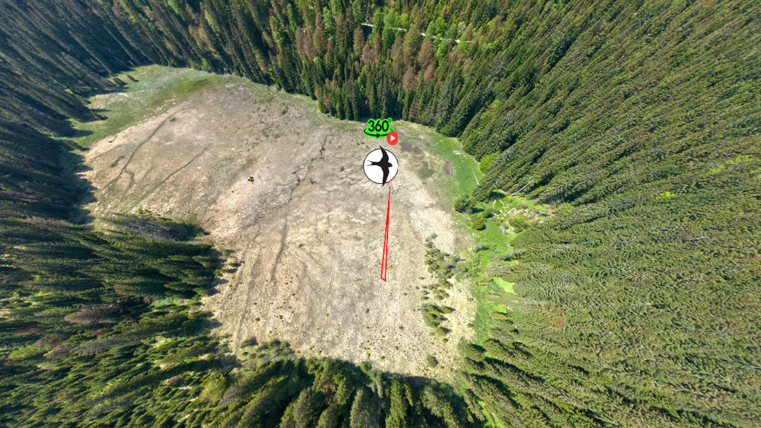
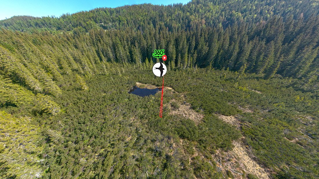
High‑Altitude Bogs on Jelovica
In addition to its forests and karst relief, Jelovica is known for its high‑altitude bogs, which are among the rarest and most sensitive ecosystems in Slovenia. These are small but exceptionally valuable wetlands that have survived on the plateau’s levelled surfaces, where a thick layer of peat has accumulated over thousands of years.
Reasons for the Formation of Bogs on Jelovica
The high‑altitude bogs on Jelovica formed due to a combination of three key factors:
1. Impermeable Substrate
Although Jelovica is predominantly a karst plateau, some of its levelled surfaces contain:
-
clay and glacial sediments,
-
patches of impermeable dolomite,
-
locally also sealed karst depressions.
These layers prevent rapid infiltration of water, allowing rainwater to accumulate.
2. Cold and Humid Climate
The plateau lies between 1000 and 1400 m above sea level, which means:
-
a long‑lasting snow cover,
-
high air humidity,
-
slow evaporation,
-
low summer temperatures.
Such conditions favour the growth of peat mosses (Sphagnum), the foundation of bog ecosystems.
3. Long‑Term Environmental Stability
The bogs developed over several millennia, as plant material accumulated faster than it decomposed. Due to the remoteness of Jelovica and minimal human impact, these fragile wetlands have been preserved in an exceptionally natural state.
Individual Bogs on Jelovica
Several small high‑altitude bogs are found on Jelovica. The most important are Ledine, Blato, Vodice, and the bog below Reberšca. Each has its own characteristics, yet they share similar ecology and a high degree of preservation.
1. Ledine Bog
Location: central Jelovica, on a levelled plateau surrounded by spruce and beech forest. Elevation: approx. 1200 m.
Characteristics
-
The best‑known and most studied bog on Jelovica.
-
Composed of several small boggy depressions interspersed with forest clearings.
-
Peat thickness exceeds 1 metre in places.
-
Vegetation includes Sphagnum mosses, bog rosemary, round‑leaved sundew, bog cypress, and rare sedge species.
Significance
-
A key site for retaining rainwater.
-
Important habitat for amphibians, butterflies, and forest‑edge birds.
-
Extremely sensitive to changes in the water regime due to its isolation.
2. Blato Bog
Location: southwestern Jelovica, on gently undulating terrain among old spruce forests. Elevation: approx. 1100–1150 m.
Characteristics
-
The name Blato (“Mud”) reflects the soft, water‑saturated ground typical of this area.
-
Smaller than Ledine but botanically very diverse.
-
Features bog hummocks interwoven with wet depressions.
-
Hosts species typical of transitional bogs (between low and raised bogs).
Significance
-
Provides an important microhabitat within the forested landscape.
-
Crucial for local amphibian populations and insects that depend on permanently moist soils.
3. Vodice Bog
Location: northeastern Jelovica, near the faulted edge above the Radovna Valley. Elevation: approx. 1250 m.
Characteristics
-
Formed in a shallow karst depression where impermeable sediments created a permanent water‑holding layer.
-
Often water‑logged for part of the year, creating marshy microhabitats.
-
Vegetation includes marsh sedge, bog bilberry, marsh horsetail, and Sphagnum mosses.
Significance
-
Due to its high moisture levels, it is an important site for marsh‑edge birds and insects dependent on standing water.
-
One of the best‑preserved wetlands on the northern edge of the plateau.
4. Bog below Reberšca
Location: eastern Jelovica, below the Reberšca ridge. Elevation: approx. 1150–1200 m.
Characteristics
-
A small but highly isolated bog, hidden within dense spruce forest.
-
Formed in a closed depression where water remains for most of the year.
-
Due to its shaded position, vegetation differs from more open bogs: dominated by dark peat mosses, marsh grasses, bog mosses, and dwarf pine.
Significance
-
Important for the genetic diversity of bog plants due to its isolation.
-
A reference example of a naturally developed high‑altitude bog with minimal human influence.
Tourism and Recreation
Jelovica is not a mass‑tourism destination, which is part of its character. Tourism is oriented primarily towards quiet, nature‑friendly recreation.
Most common activities:
-
hiking (e.g., routes from Dražgoše, Jamnik, Kropa),
-
mountain biking along forest roads,
-
cross‑country skiing in winter,
-
foraging for forest fruits,
-
visiting viewpoints (Jamnik, viewpoints above the Lipnica and Selca valleys).
Its varied relief and dense forest cover create a strong sense of seclusion, silence and natural authenticity.
History
Throughout history, Jelovica has been important mainly as a forest and pastoral area.
Key historical aspects:
-
Pastoralism: the plateau once hosted several pastures and hay meadows, now mostly abandoned.
-
Ironworking: the forests of Jelovica supplied charcoal for the ironworks of Kropa and Kamna Gorica.
-
Second World War: the area played a significant role in the partisan resistance; numerous memorials, especially in Dražgoše and on Partizanski vrh, commemorate this.
-
Forestry
The mountain pastures of Jelovica form one of the most characteristic elements of this high, forested plateau. Scattered among dense spruce and beech forests are unexpectedly bright, grassy openings – the remnants of former pastoral areas that local communities used for centuries for grazing, haymaking, and seasonal settlement. Today, these pastures are an important part of Jelovica’s cultural landscape and serve as starting points for hiking, cycling, and exploring the high‑karst environment.
Mountain pastures of Jelovica – character and distribution
Most pastures lie along the margins of the plateau, where the forest gives way to more open terrain. They are typically situated between 900 and 1,200 metres above sea level, on the transition between steep slopes descending into the surrounding valleys (Selca, Lipnica, Radovna) and the gently undulating interior of Jelovica. Because of the karstic bedrock, the soil is shallow and natural springs are almost absent, which meant that pastures depended on rainwater collection and carefully maintained watering holes.
The vegetation consists of meadow communities, gradually encroached upon by regenerating forest. In many places, traces of former hayfields, shepherds’ paths, and small levelled clearings are still visible.
Goška ravan – the most prominent pasture of the northern rim
Among all the pastures of Jelovica, Goška ravan stands out for its location, openness, and accessibility.
It lies on the northern edge of the plateau, above the Lipnica Valley, where the otherwise forested Jelovica suddenly opens into a broad, grassy expanse. This is a typical rim pasture, combining elements of high karst (sinkholes, shallow depressions, rocky shelves) with softer, meadow‑like relief shaped by centuries of human use.
On its southern edge stands the Goška ravan Mountain Hut (933 m), now the central point of the area. From here, the pasture spreads northwards and northeastwards, where the plateau breaks off into steep slopes above Spodnja Lipnica, Kamna Gorica, and Kropa. Because of this position, Goška ravan is one of Jelovica’s finest natural viewpoints, especially towards the Karavanke, the Kamnik–Savinja Alps, and the Lipnica Valley.
The role of Goška ravan in the landscape

Goška ravan was once an important pastoral area, but today it is primarily:
-
a starting point for hiking and mountain biking,
-
a space where the cultural landscape has been preserved,
-
an area with a striking contrast between open grasslands and dark spruce forest,
-
one of the few places on Jelovica where the plateau truly “opens up”.
Its location makes it a natural transition zone between the rim of the plateau and its interior, where the landscape becomes more heavily karstified and densely forested.
The mountain pastures of Jelovica are a valuable remnant of traditional land use and one of the few open elements of an otherwise forested plateau. Among them, Goška ravan holds a special place: it is the most accessible, the most scenic, and the most distinctive pasture of the northern rim, where natural and cultural landscapes merge into one of the defining images of Jelovica.