

-
Slovenian Professional Contribution:
-
Dr. Jernej Pavšič (Faculty of Natural Sciences and Engineering – NTF, University of Ljubljana): One of the key initiators and scientific leaders of the project; he led the stratigraphic and paleontological analyses of the Eocene layers, research on microfossils and ichnofossils, and co-created the professional content for the interpretation panels.
-
Dr. Tea Kolar-Jurkovšek and Dr. Bogdan Jurkovšek (Geological Survey of Slovenia – GeoZS): Participated in field geological mapping and the preparation of scientific foundations for the geotourism presentation.
-
Department of Geology, NTF (University of Ljubljana): Students, together with their colleagues from Zagreb, conducted field exercises, mapping, and geosite marking over several years.
-
Geographer Boštjan Burger (Burger Landmarks): Carried out extensive visual field documentation, high-resolution photography, and comprehensive interactive 360° panoramic digitization of key geosites, caves, and specific erosional phenomena for virtual presentation and the long-term preservation of natural heritage. As part of his geomorphological research, he thoroughly studied the phenomenon of characteristic cavities and recesses (tafoni) in sandstone and, using comparative analysis, established a direct geomorphological parallel between weathering processes in Lopar Geopark and classical tafoni occurrences in Corsica.
-
-
Croatian Partners and Local Support:
-
Dr. Ljerka Marjanac and Dr. Tihomir Marjanac (PMF Zagreb, ProGEO-Croatia Association): Principal initiators and scientific coordinators on the Croatian side.
-
Town of Rab, Municipality of Lopar, and Lopar Tourist Board: Provided logistical support, funding for informational signage, and infrastructure maintenance.
-
Mountaineering Club Kamenjak (Rab): Carried out the field routing and waymarking of the geological trails.
-
-
Eocene Flysch Formation: The lithological profile is characterized by a rhythmic alternation of harder quartz and carbonate sandstones with soft, impermeable marls and claystones.
-
Nummulites and Biostratigraphic Significance:
-
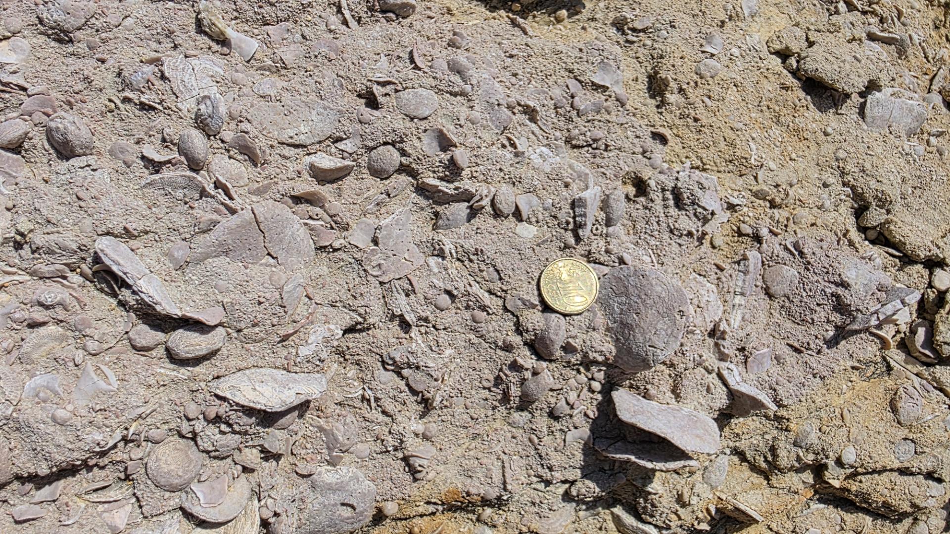
Paleoenvironmental Indicators: Nummulites (a genus of large benthic foraminifera from the order Rotaliida) were single-celled marine organisms with a spirally coiled, lenticular calcareous shell. In the warm, shallow, and sunlit Eocene Sea (Tethys), they flourished extensively, ranging in size from a few millimeters to several centimeters.
-
Sedimentation and Transport: Many nummulitic limestones and bioclastic sandstones in Lopar were formed by gravitational mass movements: currents swept nummulite skeletons from the shallow waters of surrounding carbonate platforms and deposited them as turbidites into the deeper flysch basin.
-
Index Fossils: Due to their rapid evolution and specific internal chamber morphology, distinct species of nummulites served as key index fossils. These allowed researchers (notably Dr. Jernej Pavšič) to precisely determine the relative age and stratigraphic succession of Lopar's strata. On the weathered surfaces of sandstones, the shells are visible as tiny coins or lenses (from the Latin word nummulus – small coin).
-
-
Other Paleontological Heritage: In addition to nummulites, other foraminifera (alveolines, operculines, discocyclines), mollusk remains, and exceptionally rich ichnofossils—fossilized feeding, crawling, and dwelling traces of benthic organisms in the soft seabed sediment prior to lithification—are also found.
-
The Tafoni Phenomenon and Micro-Relief Weathering:
-
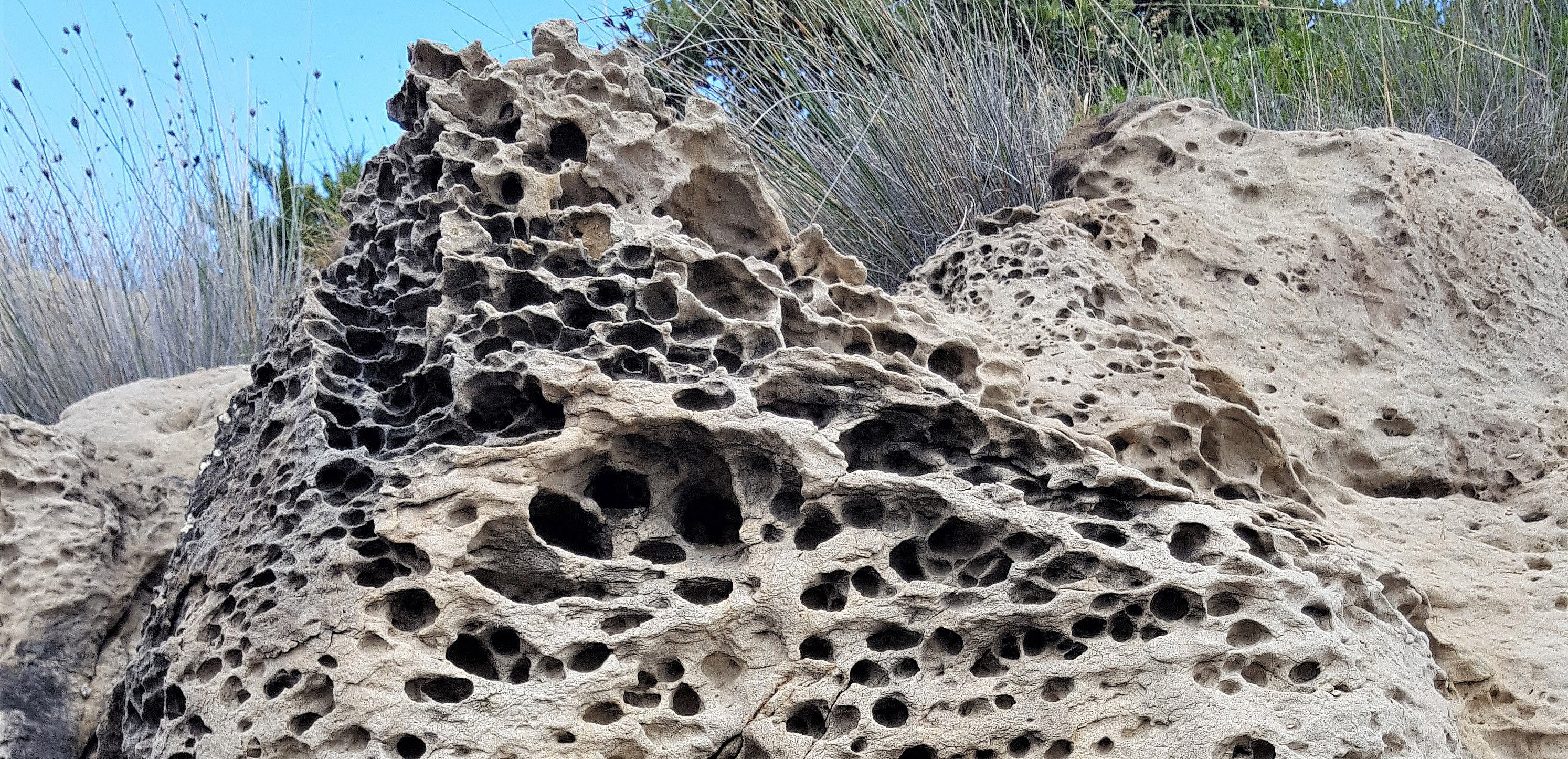
Terminological Origin and Definition: The term tafoni (tafone, taffoni) was introduced into geomorphology by Albrecht Penck in 1894 based on Corsican examples (Morphologie der Erdoberflaeche, Vol. 2). They are cavernous rock recesses formed by direct or indirect weathering of medium- to coarse-grained crystalline rocks, though under acidic agents (acidic moisture, sea spray) they also develop in sandstones, limestones, or schists.
-
Morphology and Mechanism: Tafoni frequently occur in clusters, riddling rock walls and outcrops. Their dimensions range from a few centimeters (miniature tafoni, smaller than a soccer ball) to several decimeters or even meters. Inside the cavity, they are typically elliptical or spherical with an overhanging lip. The outer crust of the tafone is case-hardened and sturdy, while the interior, subject to intensive acidic and chemical weathering, remains soft, porous, and friable even to finger pressure.
-
Causes of Formation: Although found in various climates, they are most common in coastal, arid, and semi-desert environments. Alongside chemical weathering, their development is driven by haloclasty (salt crystal growth), permeability and lithological variations in the rock, cyclic wetting and drying, and freeze-thaw action.
-
-
Other Geomorphological Processes:
-
Differential Erosion on the Lopar Peninsula: From Mysterious Caves to Earth Pyramids
In the northeastern part of the island of Rab, at the heart of the Rab Geopark, lies a landscape that gives the impression of another planet. The Lopar Peninsula is a geological uniqueness in Kvarner, where Eocene flysch sediments dominate instead of the prevalent hard limestone. Within this geological bedrock, one of the most illustrative examples of differential erosion unfolds, resulting in two seemingly different, yet genetically intertwined landforms: Lopar Caves (Grote) and Rab Pyramids.
The Common Mechanism: The Struggle Between Rock and Natural Forces
The foundation of all unusual landforms in Lopar is the alternating succession of two rock layers with different mechanical resistance:
-
Marls and poorly consolidated sands: Soft, fine-grained, and friable layers that are rapidly eroded, peeled away, and washed out by rainwater, marine aerosols, and the strong Bora wind from Mount Velebit.
-
Sandstones: Harder, compact beds that significantly better withstand mechanical weathering.
When external forces attack such a slope, the softer marl quickly retreats, while the more resistant sandstone remains in relief. Depending on the position of the protective sandstone layer, two distinct landscape profiles emerge.
Lopar Caves (Grote): Negative, Concave Landforms
When a resistant sandstone layer forms a horizontal ceiling or the upper band of a slope, water and wind first hollow out and wash away the soft marl directly beneath it.
-
Formation: Deep rock shelters, hollows, caves (grote), and prominent natural arches are created.
-
Characteristics: The upper sandstone layer overhangs open space like a natural roof or bridge, while the underlying walls are frequently covered by honeycomb weathering (tafoni).
Rab Pyramids: Positive, Prominent Landforms
If an isolated compact block of sandstone or a large boulder rests atop soft ground, it acts as a protective "cap" or umbrella.
-
Formation: Rainwater erodes and washes away all unprotected surrounding material, carving deep gullies (badlands) into the slope. Beneath the capstone, the material remains protected from direct raindrop impact.
-
Characteristics: As the surrounding ground level lowers, slender, conical pinnacles, pillars, and earth pyramids are left standing, defying time until the protective capstone on top slips off.
Landscape and Experiential Significance
This phenomenon is best observed along the northern bays of Lopar (such as Sahara, Stolac, and Podšilo) and around Cape Kaštelina. Due to the perpetual action of the sea and wind, this is a living landscape that continuously reshapes itself—old caves eventually collapse, pyramids wear down, and nature is already sculpting the next formations at new erosional focal points.
-
-
Erosional Gullies (Badlands): Due to the impermeability of marl, rainwater runs off on the surface and cuts deep ravines, creating a rugged, dissected landscape barren of vegetation cover.
-
Sand Accumulation: The mechanical breakdown of sandstones provides a constant source of clastic material, which waves and wind transport and deposit into 22 sandy bays and coastal dunes.
-
1. Ciganka Bay (Far Northwest)
-
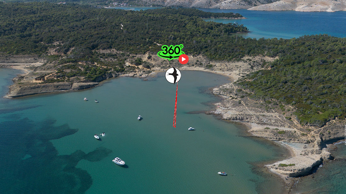
Geological Foundation and Differential Erosion: The area is composed of sedimentary rocks (predominantly Eocene sandstones and marls with varying degrees of cementation). Softer sandy and marly layers were relatively quickly washed away and blown away by rainwater, waves, and wind, while the harder, more silicified or mineral-cemented parts of the rock mass resisted erosion longer, giving rise to isolated pyramidal pinnacles and upright rock pillars (monoliths).
-
Abrasion and Wave Action: The coastline is directly open to northern and northwestern winds, allowing intense wave activity. Waves continually strike and undercut the lower strata at the base of the rock structures, creating characteristic abrasion notches, rock shelters, and overhanging cliffs. Dislodged particles are fragmented and mixed with coastal sand, while the pillars maintain their upright form until excessive undercutting causes them to collapse.
-
Aeolian Abrasion (Corrasion): The bay's northern exposure subjects it to ferocious gusts of the Bora and Tramontana winds. Strong wind lifts sharp sand grains from the dry shore and hurls them at high speed against exposed rock surfaces. This process functions like a natural sandblaster, mechanically polishing the rock, rounding its sharp edges, and creating unusual aerodynamic flutes and grooves.
-
Development of Tafoni (Honeycomb Weathering): One of the most recognizable features on the stone towers of Ciganka is the dense network of small cavities and recesses known as tafoni (or honeycomb weathering). Waves and sea mist deposit fine droplets of saline water onto the rocks. As the water evaporates on dry, windy days, salt crystals form inside the microscopic pores of the sandstone. Crystallization generates high internal pressure that disintegrates the rock structure from the inside out. Over time, micro-pores expand into characteristic semi-circular hollows, networks of cavities, and honeycomb patterns, lending the rocks the appearance of natural sculptures.Due to the interplay of these three forces—hydrodynamic sea impact, wind corrasion, and chemical-physical salt weathering—Ciganka Bay stands as an outstanding showcase of active coastal morphogenesis in the Adriatic.
2. Sturić–Dubac System (Northwestern Central Belt)
-
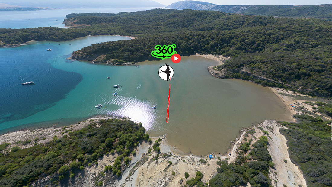
Uvala Sturić (Western Sand Lagoon): Opening on the western side of the cape, Uvala Sturić is considered one of Lopar's most iconic sandy amphitheatres. The bay floor is almost entirely blanketed with fine, pale quartz sand. The sea is exceptionally shallow, with depth increasing very gradually, creating a characteristic turquoise water hue on sunny days. Calmer hydrodynamic conditions within the cove facilitate uniform sediment deposition. Distinct ripplemarks form on the bottom, gently reconfigured with every tide and wind shift. The hinterland ascends semi-circularly into gentle sandy slopes overgrown with pine forest and indigenous scrub, protecting the area against soil erosion.
-
Cape Sturić and Sturić Islet (Mali Sturić): Cape Sturić is an elongated, rugged rocky tongue jutting northward, separating Sturić Bay to the west from Dubac Bay to the east. It is composed of harder, more cemented layers of sandstone and marl that resisted the intense erosion to which the surrounding bays succumbed. As a result of differential abrasion, characteristic rocky ledges, fissures, and small undercuts formed along the cape. Directly off the headland lies a low, rocky-sandy islet, the remnant of the former terrestrial continuation of the cape. Between the cape and the islet lies a shallow marine passage acting as a natural regulator of currents between the adjacent bays. The cape is heavily exposed to Bora gusts from Mount Velebit. Sea spray and powerful winds have stripped most soil from the ridge, leaving its surface dominated by barren patches and low, salt-tolerant macchia.
-
Uvala Dubac (Eastern Sheltered Bay): Uvala Dubac lies east of Cape Sturić, indenting deeply into the pristine landscape of the Lopar Peninsula. Because Cape Sturić partially shelters it from direct westerly and northwesterly currents, the sea in Dubac Bay is often even calmer. This allows the settling of very fine, silty sand fractions. Intermittent torrent gullies drain into the bay from the peninsula's interior. During intense autumn and winter rainfalls, these gullies carry fresh sandy material down from the slopes, naturally feeding and expanding the shoreline. At the edge of the beach, the sand gradually transitions into low coastal dunes that merge into the dense shade of pine trees (from which the bay's name originates, linked to the woodland vegetation in its hinterland).The entire complex of Cape Sturić and the Sturić and Dubac bays functions as a harmonious natural system: Cape Sturić channels and dampens open-sea wave energy, Uvala Sturić serves as an expansive, open sedimentary lagoon with dynamic sand transfer, and Uvala Dubac represents a calmer, vegetated, and torrent-fed terminus of the coastal arc. With no paved road access, a high degree of biodiversity and pristine natural coastal relief are preserved.
3. Podšilo Area with Cape Šilo (Northern Central Belt / Northern Coast)
-
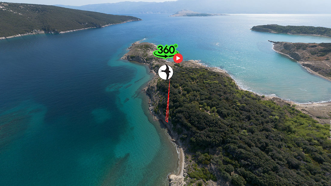
Cape Šilo (Promontory and Natural Bulwark): Cape Šilo is a prominent, wedge-shaped rocky headland extending far into the sea as a natural breakwater, dividing adjacent bays. Unlike the soft flysch and sandy coves of Lopar, the cape is built of harder, more cemented sandstone beds and carbonate sediments. This greater mechanical resistance enabled the cape to withstand millennia of marine abrasion and retain its extended form. The shoreline of the cape is steep and in several places precipitous, featuring distinct abrasion platforms and cliffs. Bora-driven waves carve deep erosional notches, undercuts, and fracture gullies at its base. The headland is directly exposed to Senj Bora gusts originating on the slopes of Mount Velebit. Wind strips topsoil from the exposed ridges, creating barren ground with highly adapted, low-growing halophytic vegetation (plants resilient to salt and wind).
-
Podšilo Bay (Sedimentary Bay and Lagoon): Podšilo Bay lies nestled directly in the lee of Cape Šilo, giving it a completely different character—a quiet, picturesque sandy cove with a rich hinterland. Due to its position below the headland, the bay is shielded from the direct impact of the most powerful northern waves. This dampens wave energy within the cove, fostering the intensive deposition of fine-grained sand and silt. The bay's hinterland consists of soft sand-marl layers covered by macchia and pine trees. Dry torrential ravines traverse this hinterland, washing fresh sand directly into the bay during heavy downpours, thereby constantly renewing the natural beach. The bay floor slopes very gently, making the water exceptionally shallow and warm. Under gentle currents and tidal cycles, regular ripplemark patterns form on the seabed. In dry periods, wind carries fine sand from the shore toward the pine forest margin, forming small coastal dunes partially stabilized by coastal plant root systems.The interplay between Cape Šilo and Podšilo Bay illustrates a complete natural cycle of coastal morphogenesis: the cape serves as a solid shield deflecting marine currents and wind, while the bay functions as a sedimentation basin catching the products of erosion from Lopar's interior. Due to limited access (primarily via footpaths or by sea), the area preserves its pristine natural dynamics without artificial coastal interventions.
4. Sahara Bay / Uvala Saramić (Northern / Northeastern Arc)
-
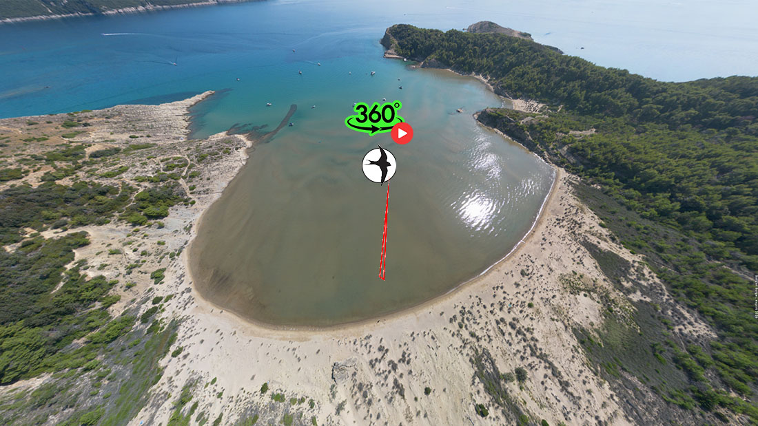
Geomorphological Amphitheatre and Hinterland: The bay is shaped as a natural semi-circular amphitheatre surrounded by the predominantly flysch and sandy terrain characteristic of the Lopar Peninsula. Unlike the majority of the rocky and karstic Adriatic coastline, soft, highly erodible sedimentary layers dominate here. The hinterland slopes steeply toward sea level in the form of dissected gullies, barren patches, and small terraces covered with low Mediterranean vegetation, macchia, and pine trees.
-
Torrential Processes and Sediment Dynamics: The primary engine driving the ongoing reshaping of the bay is the occurrence of episodic, high-intensity flash floods. During heavy rainfall, significant volumes of water rush down dry torrential channels (wadis) into the bay, stripping sand, silt, and fine sediment from the soft hinterland. Upon entering the bay, this material spreads out in a fan across the entire shoreline and shallows, continuously replenishing sand accumulations. In the hinterland, water carves miniature canyons and rills (badlands topography), bestowing a dramatic, almost desert-like atmosphere upon the landscape.
-
Dunes and Wind Influence: Once the deposited sediment dries, wind takes on the leading role. Strong gusts of Bora and Jugo transport the fine, dry sand inland, accumulating it into coastal dunes. In certain sections, these dunes are stabilized by pioneer psammophytic vegetation and root networks that prevent rapid loss of sand back into deep waters.
-
Beach and Marine Shallows: The bay opens into an extremely shallow, gently sloping sandy lagoon where seawater remains at ankle to knee depth even tens of meters from the shore. Waves and currents constantly redistribute the sand, forming prominent ripplemarks on the seabed. In the absence of road infrastructure and with its natural dynamics fully preserved, Uvala Saramić remains one of the finest examples of ongoing collaboration between precipitation, erosion, and wind on the Adriatic coast.
5. Cape Saramić and South Cape Saramić (Northeast)
-
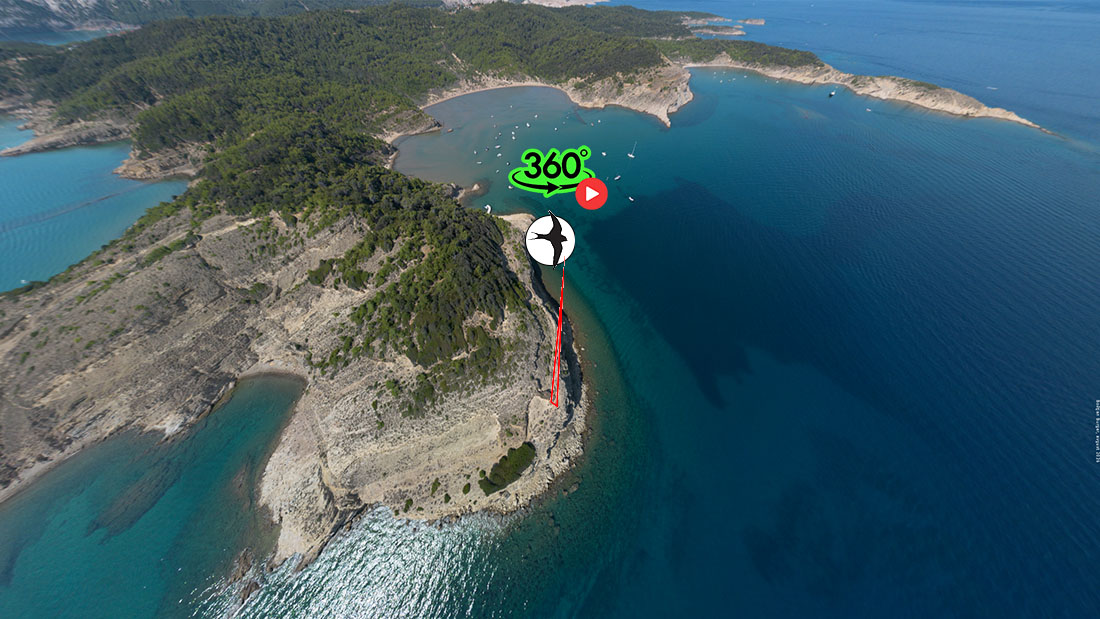
Geomorphological Features and Weathering: Similar to the wider Lopar area, both capes are formed of Eocene flysch sandstones whose softer, heterogeneous composition makes them exceptionally susceptible to external weathering. Wave and current action sculpts an intricate coastline with steep faces, small natural piers, and hidden pebble and sand pockets. Continuous sea spray combined with intense sunlight and wind causes salt weathering (coastal haloclasty). Salt crystallization within fine fissures in the sandstone produces characteristic micro-forms, such as small tafoni and localized honeycomb structures. The strong Bora wind striking this part of the island across the Velebit Channel blows away detached sand grains, further abrading and rounding the rock edges.
-
Differences Between the Two Capes:
-
Cape Saramić: The northern of the two stands out as a more exposed natural breakwater, sheltering smaller coves from direct wave impacts. Its rocks are steeper, more dissected, and offer expansive views toward neighboring islands and the magnificent backdrop of Mount Velebit.
-
South Cape Saramić: A slightly gentler and more sheltered area where rocky ledges descend gradually toward the sea. In its lee, calmer micro-environments with crystal-clear water form, particularly favored by visitors seeking complete seclusion and retreat into nature.
-
-
Accessibility and Nature Experience: The area surrounding both capes is part of Lopar's undeveloped, protected landscape belt. It is accessible via easy footpaths and trails traversing indigenous Mediterranean macchia and pine groves, as well as by sea (via kayak or small boats). Due to the lack of tourist infrastructure, the capes have retained their primal wilderness, making them prime destinations for photographers, geomorphology enthusiasts, and explorers of pristine Adriatic shorelines.
-
Geological Bedrock and Lithology: The coastal zone of Cape and Bay Stolac consists of thick-bedded flysch sandstones (Eocene in age). These sandstones exhibit a heterogeneous composition containing quartz grains, carbonate clasts, and a variable proportion of calcareous or clayey cement. This composition makes the rock ideal for differential weathering—less resistant sections break down rapidly, while harder parts form protruding ridges and ribs.
-
The Process of Haloclasty (Salt Weathering): The principal driving force shaping the rock surface at Cape Stolac is haloclasty—the physical weathering of rocks driven by salt crystallization. Strong winds (notably the Bora and Jugo) and crashing waves constantly spray seawater over the exposed rock surfaces of the supralittoral zone. During dry, sunny intervals, water quickly evaporates from fine pores, fissures, and hollows, precipitating sea salt crystals (primarily halite). As salt crystals grow within the pore spaces, they exert immense hydraulic and crystallization pressures against the pore walls, crumbling sandstone grains and flaking away the rock's outer layer.
-
Tafoni and Honeycomb Weathering: The long-term result of haloclasty combined with aeolian erosion (wind-blown removal of loosened sand) is an array of impressive micro-relief forms. Tafoni appear as large, spherical or elliptical cavities with characteristic convex, concave, or overhanging ceilings. At Cape Stolac, tafoni often coalesce into extensive galleries and cavernous complexes. Honeycomb weathering forms a dense network of smaller, centimeter-deep cells bounded by sharp dividing ribs, bearing a striking resemblance to honeycombs.Owing to the exceptional preservation and scale of these landforms, Cape and Bay Stolac constitute a vital geomorphological natural heritage and an extraordinary training ground for the study of coastal dynamics in flysch formations.